Hurricane Milton could make landfall in Florida as Category 3 storm
Tropical Storm Milton rapidly intensified into a Category 1 hurricane Sunday with its path aimed at Florida, less than two weeks after Hurricane Helene struck the state.
The hurricane is expected to make landfall on the state’s west coast on Wednesday, federal forecasters said.
“We are expecting Milton to be a hurricane as it moves across the state of Florida,” National Hurricane Center Director Michael Brennan said during a video update on Sunday.
“This is a storm that is going to be growing in size and bringing impacts to much of the Florida peninsula,” he said.
The storm debuted as a hurricane Sunday afternoon and continued to strengthen by drawing fuel from the Gulf of Mexico’s sultry waters.
Forecasters said Milton was likely to reach major-hurricane status — denoting a Category 3, 4, or 5 storm — on Monday. It’s likely to strengthen to a Category 4, which denotes sustained winds of 130 mph, in the Gulf, before weakening back to Category 3, defined by sustained winds of at least 111 mph, at landfall, according to the hurricane center and NBC News meteorologists.
Gov. Ron DeSantis said Sunday that Milton is expected to make landfall in Hillsborough or Pinellas county Wednesday evening. He preemptively issued an emergency declaration for 51 counties, including Pinellas County.

As of 11 p.m. E.T. Sunday, Milton was about 230 miles west-northwest of Progreso, Mexico, and 765 miles west-southwest of Tampa. It was pushing out maximum sustained winds estimated to be 90 mph, with some higher gusts, the hurricane center said, and moving east at 7 mph.
“On the forecast track, Milton is forecast to move just north of the Yucatán Peninsula and across the southern Gulf of Mexico Monday and Tuesday and approach the west coast of the Florida Peninsula by Wednesday,” the hurricane center said.
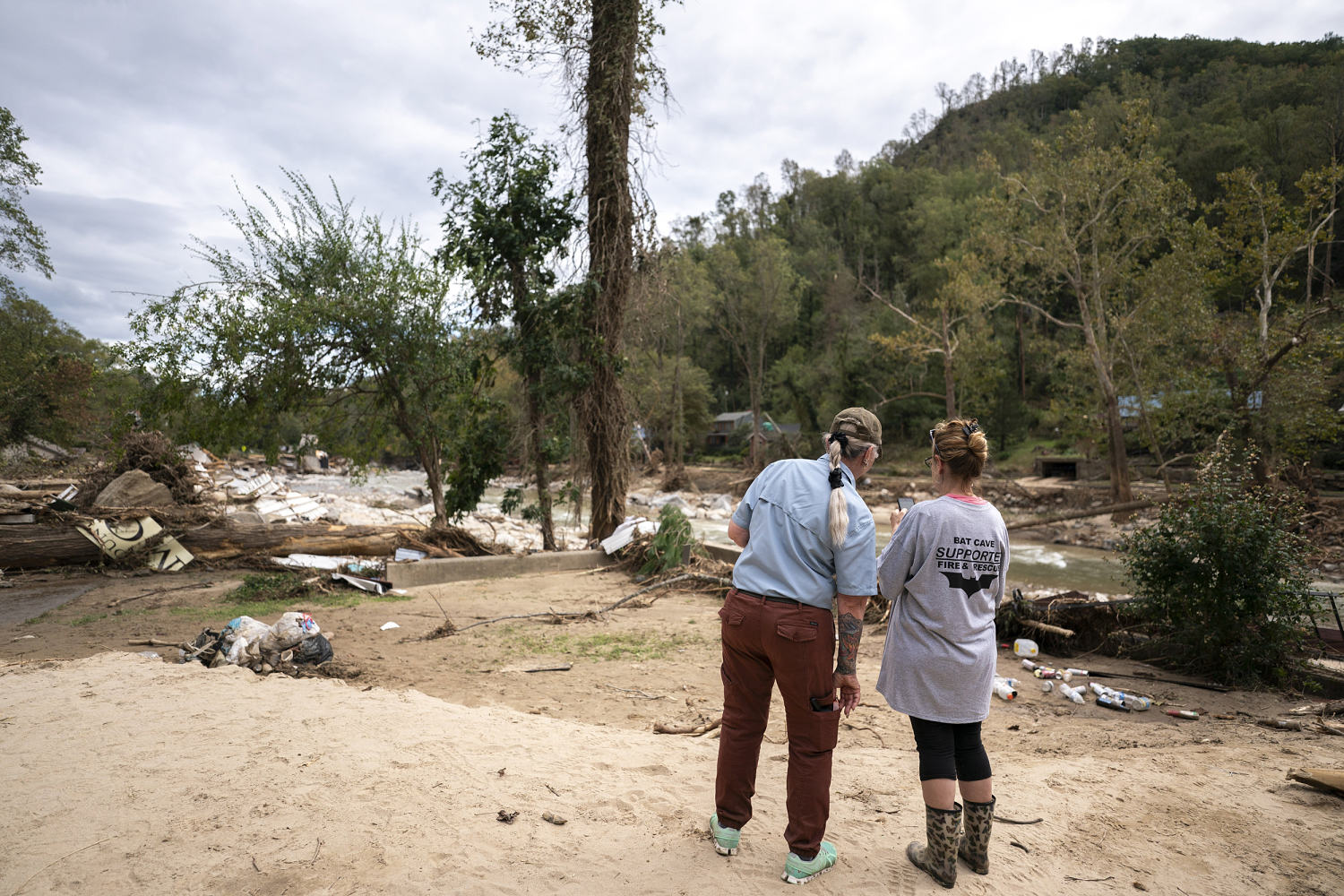
A 24/7 effort to clean up debris left over from Helene is underway in the state in anticipation for Milton, according to DeSantis. Milton’s potential impacts, which include damaging winds and storm surge, could accentuate an already bad situation, he said.
The Florida Department of Transportation said clean up crews are working around the clock to clear debris. Earlier Sunday, about 150 dump trucks and 45 other vehicles assisted the effort.
Storm surge a concern
The new hurricane status Sunday meant that watches and warnings on rain, wind and storm surges were in effect for much of the west coast of Florida less than two weeks after Helene rampaged through the Southeast.
Hurricane-force winds were forecast for midweek for the west coast from the bottom edge of the Big Bend to Naples, Brennan of the hurricane center said. There was also the potential for life-threatening storm surge along that stretch, he said.
Milton was generating waves of 6 to 9 feet in the Gulf of Mexico and would cause “life-threatening surf” on Florida’s normally small-wave west coast, federal forecasters said.
Brennan said the storm could move along the Interstate 4 corridor, which runs from Tampa to Daytona Beach, bringing with it the likelihood of flash and urban flooding as well as major river flooding. It could hit the backside of east coast communities from Jacksonville to Daytona, with the area from Orlando to Gainesville in its possible path east, he said.
“Polk County is an inland county,” Paul Womble, director of county emergency management, said during a news conference Sunday. “We don’t have hurricane evacuation zones. Our evacuations are for high winds, mobile homes, RVs.”
Five to 10 inches of rain, with up to 15 inches in some areas, is expected across parts of the Florida Peninsula and parts of the Florida Keys through Wednesday night, and with it the possibility of flash flooding and moderate to major river flooding.
The system may produce rainfall of 2 to 4 inches across portions of the northern Yucatán Peninsula as well, where storm surge may raise water levels by 2 to 4 feet above ground level, the hurricane center said. “Large and destructive waves” can be expected near the coast.
A hurricane watch was in effect for the northern coast of the Yucatán Peninsula, from Celestun to Cabo Catoche. A tropical storm warning is also in place from Celestun to Cancun.
The hurricane center is warning those in these areas, as well as in the Florida Peninsula, the Florida Keys and the Bahamas, to closely monitor this system for any potential impacts.
Residents urged to prepare
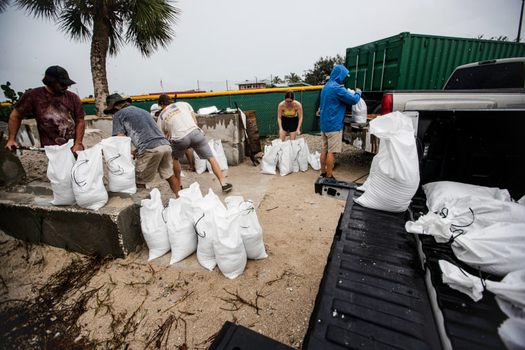
Officials urged residents along the west coast of the state to consider evacuating early to avoid traffic jams.
“Have a plan, execute the plan,” DeSantis said. “You certainly can leave now. You don’t have to wait to get an evacuation order.”
Voluntary and mandatory evacuations will likely be issued in “a number of communities,” most likely including the barrier islands, DeSantis said. A mandatory evacuation of Anna Maria Island will be ordered on Monday afternoon, according to officials.
Officials in Pinellas County, which occupies the Tampa Bay peninsula, ordered residential healthcare facilities along coastal and low-lying zones to evacuate until further notice starting Sunday afternoon, according to a county executive order.
To the immediate south, Manatee County officials said on social media platform X that residents of coastal and low-lying zones should evacuate beginning Monday afternoon. They also called on residents of RVs and mobile homes to get out at that time.
Miami-Dade County Mayor Daniella Levine Cava declared a local state of emergency out of caution ahead of Milton’s arrival, she said on X.
School districts in Pasco, Sarasota and Hillsborough counties announced that schools will be closed from Monday to Tuesday due to the incoming hurricane.
Polk County, south of Orlando, activated a citizen information phone line, started making sandbags available Sunday, and planned to open special needs and public shelters in case of evacuation Tuesday, it said in posts on Facebook.
Images from a Costco in Clearwater, Florida, showed long lines for the checkout and shopper’s carts packed with water, toilet paper, food and other essentials.
At a Walmart in Bradenton, shelves of toilet paper, paper towels and water were completely cleared out, photos showed.
Video on social media showed a family in Port Charlotte preparing their home for the incoming hurricane by installing storm shutters to their patio door.
A rare path
Since 1850, only two storms that originated in the Gulf’s Bay of Campeche have struck Florida. If Milton follows its current path, it would be the third.
Sea surface temperatures in the Gulf of Mexico are 2 to 4 degrees above average, a level of warmth correlated by earth scientists to climate change and tied to the rapid intensification of storms like Milton.
For the first time on record, the Atlantic is hosting three hurricanes, including Kirk and Leslie, simultaneously after September.
Milton will be the fifth hurricane to make landfall on the U.S. mainland in 2024, representing the second-highest number of landfalls on record and tying with 2004, 2005, and 1893.
It’s been 10 days since Helene made landfall on Sept. 26 along Florida’s Big Bend coast after sweeping north through the Gulf, causing a dozen deaths in Pinellas County, and damaging or destroying homes and businesses in the Tampa Bay area.
Twenty-five Helene-related fatalities have been reported statewide, while at least 235 people across six states have died as a result of the storm.